
Local News
KWSO FIRE UPDATE 9/24/20
Sep
Rain & wind are affect firefighting efforts. Rain fell on the fire overnight. This will reduce fire behavior and should allow crews to make even more progress. The rain was variable, but over an inch fell on some sections of the fire.
In the wake of most wildfires, there are dead trees (snags) as well as trees that are fire-weakened that tend to fall, sometimes with little warning. These trees create a hazard to firefighters as well as having the potential to block roadways needed for travel in and around the fire. Firefighters refer to these as hazard trees. When such trees are found to constitute a danger, they are cut down by crews of experienced fallers or removed with equipment.
The rainfall expected today will improve air quality. Rainfall may cause slippery roads and make travel in and around the fire difficult. Debris flows are possible, however, the amount of rain predicted is not expected to create widespread flooding.
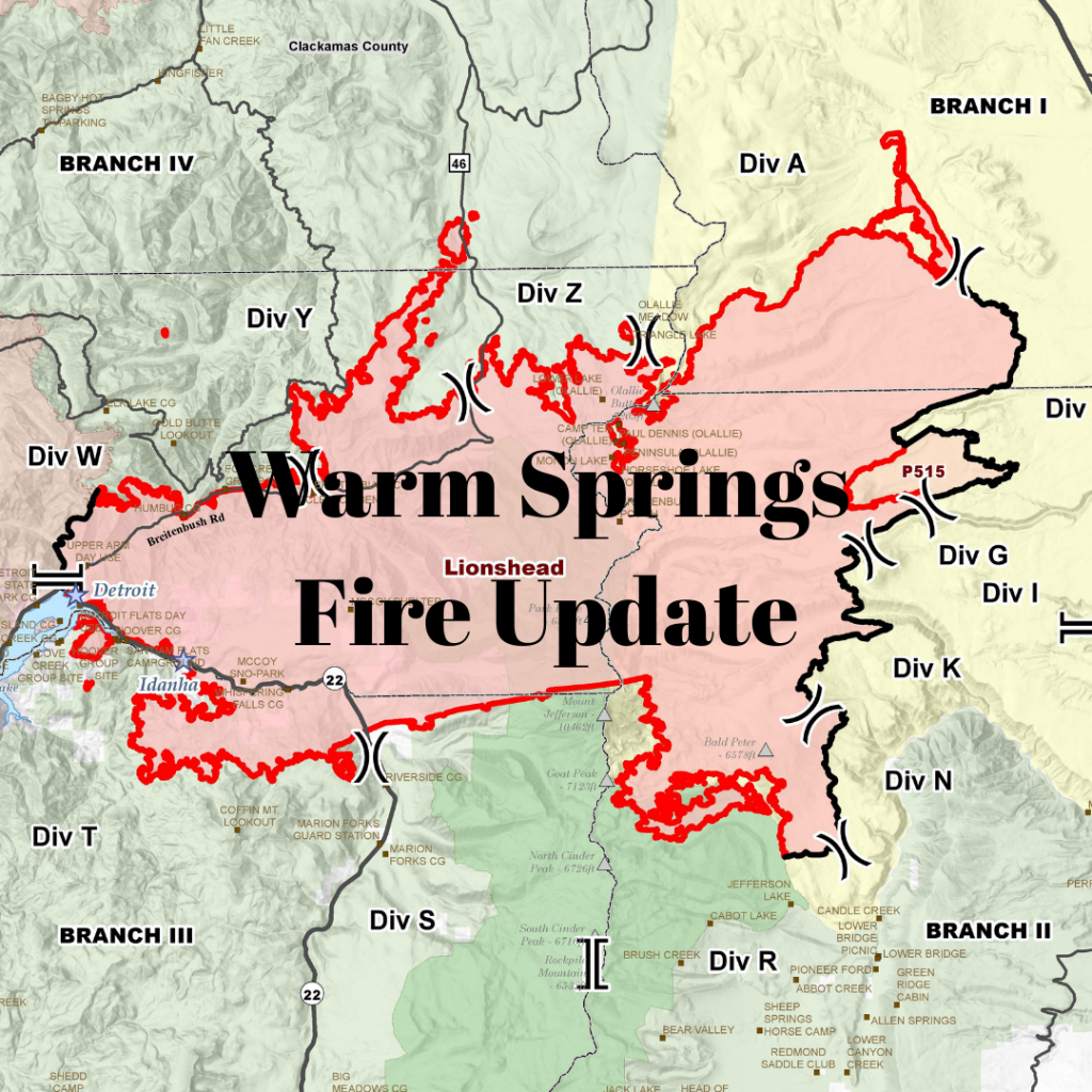
Very little movement has occurred on the north edge of the fire on the Warm Springs Reservation over the past few days. The contingency line north of the fire’s active edge is secure. This line should prevent spread of the fire if fire behavior picks up.
Progress was made in the Badger Butte area, although work continues to close a gap in constructed line. Interior islands burning out showed considerable smoke.
As the wind picked up midday on Wednesday, quite a bit of smoke was visible from the Madras and Warm Springs areas. Operations personnel on the fire reported that this smoke was coming from unburned islands of green fuels located well west containment lines on tribal lands. The burning in these areas does not endanger the effectiveness of existing fire suppression lines already constructed in these divisions. In some cases, it even makes them more secure.
On the southeast perimeter, working west from north of Jefferson Lake, the fireline has been secured west to the lava rock area. This area will be monitored by air operations and watched by lookouts. All line on the 12 Road is complete just short of the 20 Road. Firefighters still have work to do removing logs and slash.
The structure group continues their work in Detroit, Idanha, New Idanha, and Breitenbush securing line and mopping up.
Crews secured spot fires found near 46 Road. The 46 Road remains closed to the public due to the large amount of heavy equipment required for this effort. This road may remain closed until snags and other hazards are cleared and the road is deemed safe for public travel.
The north contingency group is reinforcing indirect line along the road system and is working in close coordination with Riverside Fire managers to identify opportunities to connect existing roads that both fires could use in the event these indirect lines are needed. The line is being secured with heavy equipment and hand crews removing fuels.
Roads and trails near the fire remain closed for public safety. The 12 Road will remain closed to the public for the near future. This includes roads and trails on the Confederated Tribes of Warm Spring lands adjacent to the fire and a 40-mile section of the Pacific Crest Trail between Santiam Pass and Olallie Lake. The Willamette National Forest, Bureau of Land Management, and State lands around the fire remain closed to the public.
Click HERE to read the full fire update
Click HERE to see today’s fire map