Local News
KWSO FIRE UPDATE 9/4/20
Sep
Smokey conditions will occur again today from the Lionshead Fire burning on the Warm Springs Reservation. Wind will push smoke to the northeast. Abundant dry fuels, difficult terrain and persistent burning conditions with very active fire behavior into the overnight hours is expected.
The Lionshead Fire is now 9,989 acres and 31% contained. The fire has progressed farther to the west and southwest, moving up the Whitewater River and Milk Creek drainages. The fire has pushed the southwest flank, crossing an established dozer line. Air resources have continued to work on slowing spread, with multiple heavy air tankers dropping retardant on the southern flank throughout the afternoon. Helicopter resources, including the Air National Guard supported ground resources throughout the afternoon, yesterday.
That work will continue today, as crews work to determine possible fire line locations in the southwest flank. On the NW flank, crews will continue to look for opportunities to extend line to the west.
The P-515 fire remains in mop up and patrol status. Resources no longer needed on P-515 are assisting crews on the Lionshead fire. As resources reach their 14-day limit, they are being demobilized as appropriate to meet operational needs.
The following road closures remain in effect to allow safe access for fire fighters. Please avoid these areas to ensure everyone’s safety.
Closures:
- Trout Lake Road at pavement end
- Road B140 at Potter’s Pond
- Road B210 and Road P-500
- All trails south of Trout Lake, west of M-120 Metolius Bench, east of Mt. Jefferson, and north of J-195.
- Tenino Road (P-200)
You can read this morning’s full report HERE
Today’s fire map is availalble HERE
==
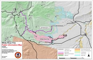
Today on the, 17,379 acre, White River Fire north of Warm Springs: On the northwest and eastern sides of the fire, crews and heavy equipment operators will reinforce established containment lines, mop up smoldering fuels near the perimeter, and plan for rehabilitating areas impacted by suppression efforts. The structure protection group will continue to mop up and patrol in the Pine Grove area. In the southwest section of the fire, crews will scout for and develop containment line in steep and complex terrain near the White River.
Evacuations and Forest Closures may impact holiday weekend activities in the area. Check Wasco County Sheriff’s Office Facebook page (facebook.com/wascocountysheriff) and the Mount Hood National Forest website (https://www.fs.usda.gov/mthood/) for details.
Evacuations: The Wasco County Sheriff has updated evacuation notices. For the most up-to-date information please visit the Wasco County Sheriff’s Office Facebook page (www.facebook.com/WascoCountySheriff). An interactive evacuation map can be found at https://arcg.is/1janHC .
Wasco County residents are encouraged to register for Wasco County Citizen Alert at: https://member.everbridge.net/index/453003085612392#/login All emergency information including evacuations will be distributed through the citizen alert system.
FOR ADDITIONAL FIRE INFORMATION:
Inciweb: https://inciweb.nwcg.gov/incident/7013